Stage one of the City of Surrey’s “Clayton Corridor Plan” has been approved.
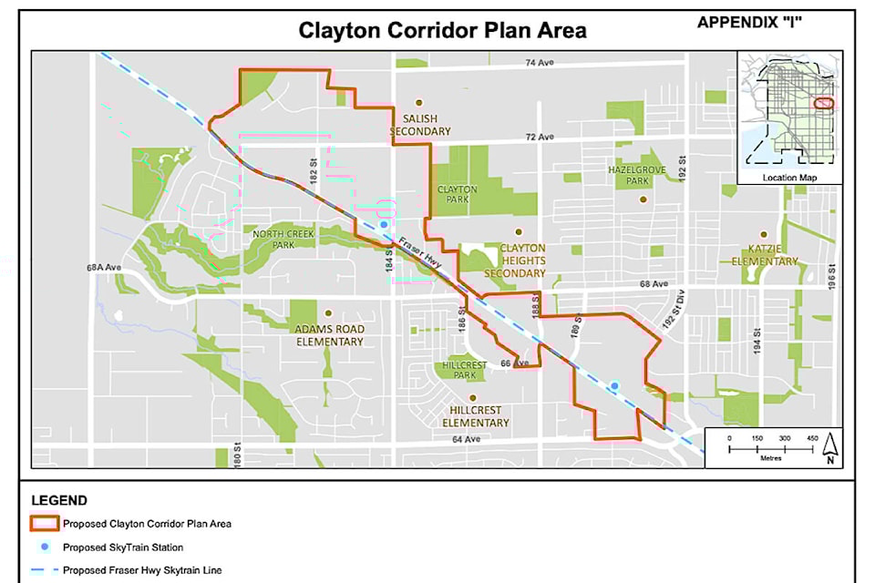
The document notes two Skytrain stations are proposed for the area, one at 184th Street and one to be locaated at approximately 190th Street.
Corporate Report R155 was approved at city council’s regular meeting July 25.
“The intent of this report is to provide an update on the Clayton Corridor Plan process and to seek endorsement of the associated Plan Area boundary,” it said in the report, submitted on behalf of three city employees: Planning & Development’s Jeff Arason, Engineering’s Scott Neuman, and Parks & Rec.’s Laurie Cavan.
“This report also seeks endorsement of the Interim Clayton Corridor Development Expectations Policy and the associated amendments to Surrey Zoning bylaw,” the report continued.
City Council approved the three items in the report: 1.) proposed plan Area boundary for the Clayton Corridor Plan, 2.) amendments to Surrey Zoning bylaw, 1993, No. 12000, to adjust Community Specific Community Amenity Contribution rates for the Clayton area based upon the density bonus concept, and 3.) authorize the City Clerk to bring forward the related bylaw for the required readings and to set a date for Public Hearing.
PLAN AREA BOUNDARY
Boundaries for the “Clayton Corridor” have been established in two general areas north of Fraser Highway, one encompassing the area from about 180th Street down to 186th Street, and another from both Hillcrest Village and Clayton Crossing shopping centres down to Fraser Highway and 64th Avenue.
Proposed Skytrain Stations have been located north of Fraser Highway on the west side of 184th and halfway between 189th Street and 64th Avenue (approximately 190th), also north of Fraser Highway (see Map 1 above).
BYLAW AMENDMENTS
The approved bylaw amendment proposes to rezone both the Cloverdale Community Map (Map-2 above) and the Clayton Community Map (Map-3 above) and increase the community contribution rates for both zones.
This now changes the “Amenity Contributions for Apartment Use” from $161.46 per sq. m ($15 per sq. ft.) to $376.73 per sq. m ($35 per sq. ft.)
A public hearing will be set for these amendments at a later date.
DEVELOPMENT POLICY
The Clayton Corridor Interim Development Expectations policy governs a wide range of issues related to development.
“This Interim Policy establishes guidelines to provide landowners, developers and buyers and sellers of lands in the Clayton Corridor Plan Area with clarity regarding the City’s expectation for consideration of rezoning and development,” reads the policy statement in Appendix III of the report. “The Policy applies to the Plan Area and applies to all development applications involving rezoning.”
This policy covers land-use planning as the Surrey to Langley Skytrain project gets underway in the Clayton Corridor. The project planning is scheduled to be finalized by 2024.
The policy also covers a number of other things, including consideration of rezoning applications requiring plan amendments, expectations for amenity contributions, density and land use designation expectations, capital project community amenity contributions exemptions, family and affordable housing policies, urban design guidelines for development, and development permit areas.
BACKGROUND
The process for the Clayton Corridor Plan began in 2019.
City staff “identified the sequence of planning along the corridor, starting with the Fleetwood Plan and following with a process to update existing plans within Clayton Heights and Cloverdale,” according to Corporate Report R155.
Back then, council approved a draft of the Fleetwood Plan, which focused on planning the Skytrain corridor in Fleetwood. City staff then piggybacked on that plan to initiate the Clayton Corridor Plan.
In May 2022, the city started working on the Clayton Corridor Plan, which included public engagement.
SEE ALSO: Surrey council to consider holding development along new SkyTrain route
That engagement “intended to introduce the planning process to residents and stakeholders” in order to “clarify key planning parameters including a Plan Area boundary, an updated community vision, and a set of interim development expectation policies to guide development interests.”
The Clayton Corridor Plan Area (Map-1) covers 277 acres primarily in Clayton. The city expects redevelopment of the area “in the short to mid-term” in the areas around the Skytrain stations.
The plan area includes portions of the existing East Clayton Neighbourhood Concept Plan, East Clayton Transit Oriented Area Plan, West Clayton NCP, North Cloverdale East NCP, and North Cloverdale West NCP.
“This planning process will update portions of some of these plans, focusing on areas around SkyTrain stations along Fraser Highway,” the report said.
The report explained that established neighbourhoods and other areas further away from the two proposed stations were intentionally left out of the Clayton Corridor Plan Area
“This is particularly relevant in areas like West and East Clayton where existing NCPs continue to provide clear and relevant development parameters to much of the area.”
editor@cloverdalereporter.com
Like us on Facebook and follow us on Twitter